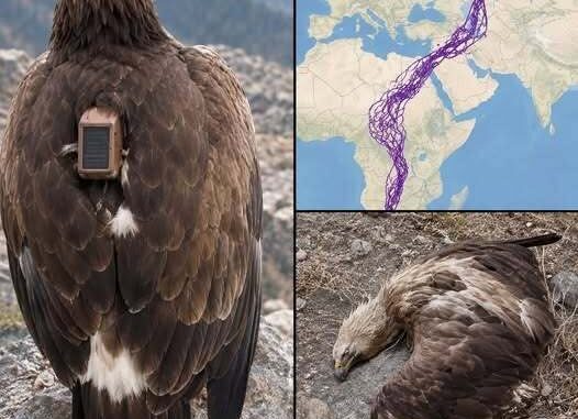
One of the most interesting details shown on the eagle’s recorded journey was its apparent avoidance of two of the region’s most prominent bodies of water: the Caspian Sea and the Red Sea.
The bird’s movements were tracked over a remarkably long period, producing a route that crossed a large portion of the Middle East and surrounding regions. When the journey was displayed on a map, one particular pattern stood out. Although the eagle traveled across several countries, its route appeared to pass around the Caspian Sea and the Red Sea rather than directly over or through these areas.
This unusual pattern naturally raises questions. Was the eagle intentionally avoiding these bodies of water, or was the route simply the result of its normal movements, migration patterns, environmental conditions, and access to food?
At this point, there is no confirmed explanation.
An Unusual Pattern on the Map
GPS tracking has provided researchers with an increasingly detailed way to observe the movements of birds and other wildlife. Instead of relying only on occasional sightings, scientists can use tracking devices to record an animal’s location over extended periods.
In this case, the recorded route offered a remarkable visual representation of the eagle’s movements. The map showed the bird traveling across a broad geographical area, making the apparent gaps around the Caspian Sea and Red Sea particularly noticeable.
However, an interesting pattern on a map should not automatically be interpreted as evidence of intentional behavior.
There are many possible reasons why a bird might follow one route instead of another. Geography, weather, wind conditions, food availability, breeding areas, seasonal migration, competition, and other environmental factors can all influence the movements of a bird.
Without additional research, it would be difficult to determine which factor, or combination of factors, influenced this particular journey.
GPS Can Show Where a Bird Went, But Not Always Why
One of the most important points when interpreting animal-tracking data is the difference between movement and motivation.
A GPS device can provide information about an animal’s location. Depending on the tracking system, researchers may be able to determine where the animal traveled, how far it moved, and how its route changed over time.
What the device cannot necessarily reveal is the animal’s reason for making each decision.
For example, if a tracking map shows a bird traveling around a body of water, that does not automatically prove that the bird was deliberately avoiding the water. The route could have been influenced by prevailing winds, available food, landscape features, temperature, seasonal conditions, or the bird’s established migration corridor.
The same principle applies to other wildlife studies. A movement pattern can provide valuable evidence, but interpreting the reason behind that pattern usually requires additional information.
In the case of the eagle, the available account highlighted the route but did not provide a confirmed scientific explanation for why the bird appeared to avoid the Caspian Sea and Red Sea.
The Caspian Sea and Red Sea
The two bodies of water are geographically significant and very different from one another.
The Caspian Sea is the world’s largest inland body of water. It lies between Europe and Asia and is surrounded by several countries, including Russia, Kazakhstan, Turkmenistan, Iran, and Azerbaijan.
The Red Sea, meanwhile, lies between northeastern Africa and the Arabian Peninsula. It forms an important geographical corridor between the Mediterranean region and the Indian Ocean through connected waterways.
Because both bodies of water are so prominent on a regional map, an animal route that appears to pass around them can immediately attract attention.
For readers looking at a GPS map, the pattern may seem intentional. However, the visual impression alone cannot establish the reason behind the eagle’s route.
Could Geography Have Influenced the Journey?
Geography is an important factor in understanding bird movement.
Birds do not travel across landscapes in exactly the same way humans do when looking at a map. Their routes can be shaped by mountains, coastlines, valleys, deserts, rivers, forests, wetlands, and other geographical features.
Large bodies of water can also influence movement, particularly for species that depend on land-based food sources or prefer certain types of terrain.
Some birds are capable of crossing significant distances over water, while others may be more likely to follow land corridors. Different species have different abilities and migration strategies.
For this reason, the apparent route around the Caspian Sea and Red Sea could potentially have several explanations. But without species-specific research and detailed environmental data, it would be inappropriate to claim that the eagle consciously chose to avoid these seas.
Weather and Wind May Also Matter
Weather conditions are another important consideration when studying bird migration.
Many large birds are capable of using rising air currents and favorable winds to reduce the energy required for long-distance travel. Certain geographical areas can provide better conditions for soaring than others.
Changes in wind direction or weather patterns may therefore influence the route a bird takes.
A bird may travel hundreds or thousands of kilometers while making decisions that are closely connected to the conditions it encounters along the way. What appears to be a carefully planned route on a map may actually be the result of repeated responses to environmental conditions.
This is one reason scientists generally need more than a single tracking map to explain animal behavior.
A Journey Across a Huge Region
Regardless of the mystery surrounding the two seas, the scale of the eagle’s journey remains one of the most remarkable aspects of the story.
The tracking data reportedly showed the bird traveling through numerous countries and across a substantial geographical area. Rather than remaining within one relatively small territory, the eagle’s movements covered a distance large enough to make the journey particularly noteworthy.
For readers, the map provides a simple way to understand this scale.
A list of countries and distances can be difficult to visualize. A line drawn across a map, however, immediately demonstrates how far the animal traveled and how widely its movements were distributed.
The GPS route therefore became more than just a collection of coordinates. It offered a visual record of the bird’s life and movements over an extended period.
Why the Route Became the Focus of the Story
The most compelling aspect of the tracking information was not necessarily a single destination. Instead, it was the overall pattern created by thousands of individual movements.
When viewed together, those movements formed a journey stretching across a large section of the region.
The apparent avoidance of the Caspian Sea and Red Sea added another layer of curiosity. It encouraged readers to ask whether there was an underlying reason for the route.
However, the responsible interpretation is to separate what the tracking data actually demonstrated from what observers might speculate.
The data could show the locations recorded by the GPS device. It could show that the eagle moved through certain regions while apparently spending less time in or around others.
What it could not independently establish was the bird’s intention.
An Open Question Rather Than a Confirmed Mystery
Stories about wildlife often become more interesting when there is an unanswered question. In this case, the eagle’s route raises a natural question about its apparent relationship with two major bodies of water.
But the absence of an explanation does not necessarily mean that the behavior was mysterious in a scientific sense.
There may be an ordinary ecological explanation that simply was not addressed in the original report. Researchers might need information about the eagle’s species, age, migration history, weather conditions, food sources, seasonal changes, and habitat preferences before reaching a meaningful conclusion.
Therefore, the safest interpretation is that the GPS data revealed an intriguing movement pattern, while the reason for that pattern remained uncertain.
What the Journey Tells Us About Wildlife Tracking
The story also demonstrates why modern tracking technology has become so valuable in wildlife research.
In the past, scientists often had to rely on direct observation, physical markings, occasional sightings, or recovered tags. Modern GPS technology can provide much more detailed information about where animals travel.
Long-term tracking can reveal migration corridors, seasonal movements, changes in territory, and connections between distant habitats.
For large migratory birds, this information can be especially useful. Understanding where birds travel can help researchers identify important habitats and potential environmental threats along their routes.
At the same time, tracking data must be interpreted carefully. A map can provide an extraordinary amount of information, but it still represents only one part of a much larger scientific picture.
The Bigger Picture
The eagle’s journey is remarkable because of both its distance and the questions raised by its route.
The apparent avoidance of the Caspian Sea and Red Sea is certainly an interesting feature when viewed on a map. Yet there is currently no confirmed explanation in the account for why the eagle followed that particular path.
Rather than presenting the route as proof of a deliberate decision, it is more accurate to describe it as an observation that deserves further investigation.
The journey also reminds us how little we may understand about the movements of individual wild animals. A bird can cross multiple countries and cover enormous distances while responding to environmental conditions that may not be visible to someone looking at a map.
Conclusion
The eagle’s GPS-recorded journey provides a fascinating look at the scale of movement possible in the natural world. Its route across numerous countries, combined with the apparent avoidance of the Caspian Sea and Red Sea, creates an intriguing geographical pattern.
However, the map alone cannot explain the reason behind that pattern.
GPS tracking can tell us where an animal traveled, but understanding why it traveled that way requires additional evidence. Geography, weather, wind, food availability, habitat, migration behavior, and seasonal conditions could all potentially play a role.
For now, the route remains an interesting observation rather than a scientifically confirmed mystery. What is clear is that the eagle’s journey demonstrates the extraordinary distances that wildlife can cover and the valuable insights that long-term tracking can provide.
The unanswered questions may ultimately be just as interesting as the journey itself.
Leave a Reply